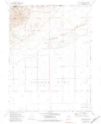
1969 Map of Lone Rock NW
USGS Topo · Published 1983About this map
The Carson Sink dominates this arid landscape at the close of the 1960s, appearing here as an expansive Alkali Flat. To the northwest, the West Humboldt Range rises sharply, marking the transition from the low desert floor to high-elevation terrain. This survey captures a moment when the desert was increasingly utilized for technical and military purposes, evidenced by a Communication Facility and a Navy Bombing Target Area situated in the southeast. Sparse human activity is limited to a single Gravel Pit and a network of Jeep Trails that cross the shifting Sand Dunes. The boundary between Pershing and Churchill counties is also clearly defined, illustrating how administrative lines were drawn across this desolate environment.
Find a feature on this map
9 named features on this map. Tap any name to fly to it.
Don’t see what you’re looking for? This feature index may not catch every label — zoom into the map to look around manually.
Map Details
Editions of this 1969 Lone Rock NW Map
2 editions found
Other maps of this area

1908 · Carson Sink
USGS Topo · 1:250,000

1910 · Carson Sink
USGS Topo · 1:250,000

1931 · Lovelock
USGS Topo · 1:250,000

1935 · Lovelock
USGS Topo · 1:250,000

1951 · Carson Sink
USGS Topo · 1:62,500

1955 · Lovelock
USGS Topo · 1:250,000

1956 · Toulon
USGS Topo · 1:62,500

1956 · Lovelock
USGS Topo · 1:62,500

1957 · Reno
USGS Topo · 1:250,000

1959 · Lovelock
USGS Topo · 1:250,000