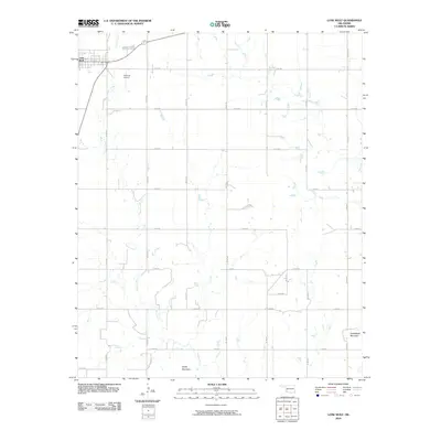
2010 Map of Lone Wolf
USGS Topo · Published 2010About this map
Lone Wolf anchors the northwest corner of this Kiowa County landscape, where the prairie begins to rise into distinct peaks. The topography is defined by the winding course of Tepee Creek, which meanders southward through a grid of section-line roads that organize the region's agricultural layout. Local elevation is punctuated by two notable landmarks in the southern half of the quadrangle: Tepee Mountain and Camelback Mountain. Aviation history is noted by the presence of Hohman Airport just east of the primary settlement. The map reveals a strictly structured rural environment, where the precise alignment of roads like N2100 Rd and E1400 Rd facilitates transport across a terrain shaped by intermittent drainage and the sudden transition from flatland to isolated mountains.
Find a feature on this map
23 named features on this map. Tap any name to fly to it.
Don’t see what you’re looking for? This feature index may not catch every label — zoom into the map to look around manually.
Map Details
Editions of this 2010 Lone Wolf Map
This is the sole edition of this map. No revisions or reprints were ever made.
Other maps of this area

1955 · Lawton
USGS Topo · 1:250,000

1955 · Clinton
USGS Topo · 1:250,000

1957 · Clinton
USGS Topo · 1:250,000

1961 · Hobart
USGS Topo · 1:62,500

1961 · Retrop
USGS Topo · 1:62,500

1963 · Babbs
USGS Topo · 1:24,000

1964 · Lone Wolf
USGS Topo · 1:24,000

1964 · Warren
USGS Topo · 1:24,000
1964 · Roosevelt
USGS Topo · 1:24,000

1971 · Blair
USGS Topo · 1:24,000