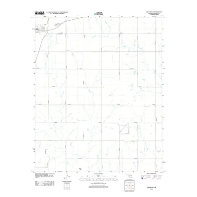
2012 Map of Lone Wolf
USGS Topo · Published 2012About this map
Lone Wolf anchors the northwestern corner of this Kiowa County landscape, organized by a precise grid of rural roads and the meandering path of Tepee Cr. The town's historic residential streets, including Day Ave and 7th St, lead toward the Lone Wolf Cem just north of town. This agricultural and aviation-linked corridor is home to Hohman Airport, situated along E1400 Rd amidst the section lines. The terrain is largely defined by wide open plains, broken only by distinctive geological formations in the south like Camelback Mtn and Tepee Mtn. This map documents the persistent layout of western Oklahoma's rural infrastructure, from its small-town center to the outlying section-line roads that facilitate the region's farming economy.
Find a feature on this map
32 named features on this map. Tap any name to fly to it.
Don’t see what you’re looking for? This feature index may not catch every label — zoom into the map to look around manually.
Map Details
Editions of this 2012 Lone Wolf Map
This is the sole edition of this map. No revisions or reprints were ever made.
Other maps of this area

1955 · Lawton
USGS Topo · 1:250,000

1955 · Clinton
USGS Topo · 1:250,000

1957 · Clinton
USGS Topo · 1:250,000

1961 · Hobart
USGS Topo · 1:62,500

1961 · Retrop
USGS Topo · 1:62,500

1963 · Babbs
USGS Topo · 1:24,000

1964 · Lone Wolf
USGS Topo · 1:24,000

1964 · Warren
USGS Topo · 1:24,000
1964 · Roosevelt
USGS Topo · 1:24,000

1971 · Blair
USGS Topo · 1:24,000