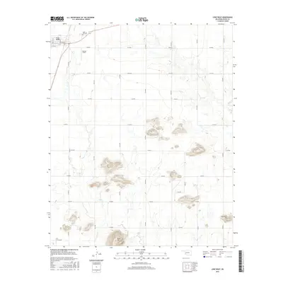
2016 Map of Lone Wolf
USGS Topo · Published 2016About this map
The town of Lone Wolf anchors this Kiowa County landscape, positioned near the intersection of the regional road network in southwest Oklahoma. The settlement, which includes the Lone Wolf Cem to the northeast, is situated in a transition between flat agricultural plains and the distinctive rises of the Wichita Mountains region. To the south, Tepee Mtn and Camelback Mtn emerge as prominent landmarks above the surrounding terrain. The drainage of Tepee Cr and Elk Cr defines the local topography, influencing the placement of the section-line roads like E1400 Rd and N2100 Rd. For those interested in local aviation and infrastructure, Hohman Airport is located just south of the town center.
Find a feature on this map
29 named features on this map. Tap any name to fly to it.
Don’t see what you’re looking for? This feature index may not catch every label — zoom into the map to look around manually.
Map Details
Editions of this 2016 Lone Wolf Map
This is the sole edition of this map. No revisions or reprints were ever made.
Other maps of this area

1955 · Lawton
USGS Topo · 1:250,000

1955 · Clinton
USGS Topo · 1:250,000

1957 · Clinton
USGS Topo · 1:250,000

1961 · Hobart
USGS Topo · 1:62,500

1961 · Retrop
USGS Topo · 1:62,500

1963 · Babbs
USGS Topo · 1:24,000

1964 · Lone Wolf
USGS Topo · 1:24,000

1964 · Warren
USGS Topo · 1:24,000
1964 · Roosevelt
USGS Topo · 1:24,000

1971 · Blair
USGS Topo · 1:24,000