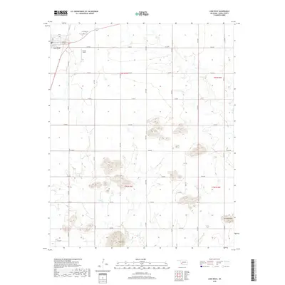
2018 Map of Lone Wolf
USGS Topo · Published 2018About this map
The settlement of Lone Wolf anchors the northwestern corner of this Kiowa County landscape, where the town grid is defined by Main St and numbered streets. The local geography is marked by several distinctive peaks rising from the plains, most notably Tepee Mtn in the south and Camelback Mtn to the east. These elevations contrast with the drainage basins of Tepee Cr and Elk Cr, which wind through the township sections. For those researching local history, the Lone Wolf Cem and Hohman Airport provide specific points of interest within the broader agricultural network of rural roads. The area is divided between the T6N and T5N townships, with a rigid system of section lines and range roads such as N2120 Rd and E1430 Rd facilitating travel across this Western Oklahoma terrain.
Find a feature on this map
34 named features on this map. Tap any name to fly to it.
Don’t see what you’re looking for? This feature index may not catch every label — zoom into the map to look around manually.
Map Details
Editions of this 2018 Lone Wolf Map
This is the sole edition of this map. No revisions or reprints were ever made.
Other maps of this area

1955 · Lawton
USGS Topo · 1:250,000

1955 · Clinton
USGS Topo · 1:250,000

1957 · Clinton
USGS Topo · 1:250,000

1961 · Hobart
USGS Topo · 1:62,500

1961 · Retrop
USGS Topo · 1:62,500

1963 · Babbs
USGS Topo · 1:24,000

1964 · Lone Wolf
USGS Topo · 1:24,000

1964 · Warren
USGS Topo · 1:24,000
1964 · Roosevelt
USGS Topo · 1:24,000

1971 · Blair
USGS Topo · 1:24,000