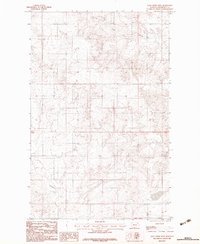
1983 Map of Long Creek West
USGS Topo · Published 1983About this map
The Fort Peck Indian Reservation landscape is defined by the high plateau drainage systems and intricate coulees of Roosevelt County in the late 1970s. This survey, compiled from 1975 aerial photography, details the rugged breaks and terrain variations characteristic of the region. Water remains the primary shaper of the land here, with Long Creek winding across the northern sections and Boxelder Creek cutting through the southwestern corner. The map also includes a notable terrain marker identified simply as Elder, situated within the expansive topography of the Missouri River watershed. While sparse in permanent settlements, the map provides a precise layout of the unimproved roads and trails that connected this section of the reservation, illustrating the rural infrastructure and land use patterns prior to the 1980s.
Find a feature on this map
5 named features on this map. Tap any name to fly to it.
Don’t see what you’re looking for? This feature index may not catch every label — zoom into the map to look around manually.
Map Details
Editions of this 1983 Long Creek West Map
This is the sole edition of this map. No revisions or reprints were ever made.
Other maps of this area

1910 · Cuskers
USGS Topo · 1:62,500

1912 · Chelsea
USGS Topo · 1:62,500

1912 · Hay Creek
USGS Topo · 1:62,500

1912 · Poplar
USGS Topo · 1:62,500

1915 · Cuskers
USGS Topo · 1:62,500

1954 · Wolf Point
USGS Topo · 1:250,000

1958 · Wolf Point
USGS Topo · 1:250,000

1972 · Chelsea
USGS Topo · 1:24,000

1972 · Chelsea NW
USGS Topo · 1:24,000
1972 · Badger Creek
USGS Topo · 1:24,000