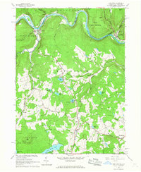
1965 Map of Long Eddy
USGS Topo · Published 1967About this map
The Delaware River forms a serpentine border between New York and Pennsylvania, anchoring a landscape of tight river bends and steep hillsides. Along its northern banks, the Erie-Lackawanna railroad tracks follow the river's path, connecting the riverside settlements of Lordville and Long Eddy. Across the water in Pennsylvania, Equinunk sits at the confluence of Equinunk Creek, marking a transition from the industrial transport corridor of the river valley to the more isolated upland plateaus of Manchester and Damascus townships.
Find a feature on this map
57 named features on this map. Tap any name to fly to it.
Don’t see what you’re looking for? This feature index may not catch every label — zoom into the map to look around manually.
Map Details
Editions of this 1965 Long Eddy Map
3 editions found
Other maps of this area

1892 · Honesdale
USGS Topo · 1:62,500

1920 · Long Eddy
USGS Topo · 1:62,500

1920 · Damascus
USGS Topo · 1:62,500

1921 · Long Eddy
USGS Topo · 1:48,000

1923 · Damascus
USGS Topo · 1:62,500

1923 · Long Eddy
USGS Topo · 1:62,500

1924 · Starrucca
USGS Topo · 1:48,000

1926 · Starrucca
USGS Topo · 1:62,500

1930 · Starrucca
USGS Topo · 1:48,000

1933 · Starrucca
USGS Topo · 1:62,500