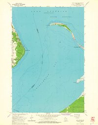
1964 Map of Long Island
USGS Topo · Published 1965About this map
Washburn sits along the western shoreline of Chequamegon Bay, serving as a focal point for this mid-1960s maritime landscape. The geography is defined by the sweeping arc of Long Island and its extension at Chequamegon Point, which separates the bay from the South Channel of Lake Superior. Navigational aids like the La Pointe Light and Chequamegon Point Light mark this hazardous coastal reach, while the interior of Long Island falls within the jurisdiction of Sanborn Twp. On the mainland, industrial activity is noted via Quarries and the tracks of the Chicago and North Western railroad that parallel the coast. The map provides depth soundings across the bay, illustrating the underwater topography near landmarks like Houghton Point and the marshy inlet at Wood Cr Slough near Oak Point. This survey captures the region's character as a junction of rail transport and Lake Superior shipping routes.
Find a feature on this map
18 named features on this map. Tap any name to fly to it.
Don’t see what you’re looking for? This feature index may not catch every label — zoom into the map to look around manually.
Map Details
Editions of this 1964 Long Island Map
This is the sole edition of this map. No revisions or reprints were ever made.
Other maps of this area

1941 · Bayfield
USGS Topo · 1:48,000

1942 · Ashland
USGS Topo · 1:48,000

1943 · Odanah
USGS Topo · 1:48,000

1945 · Odanah
USGS Topo · 1:48,000

1946 · Bayfield
USGS Topo · 1:48,000

1947 · Ashland
USGS Topo · 1:48,000

1953 · Ashland
USGS Topo · 1:250,000

1958 · Ashland
USGS Topo · 1:250,000
1964 · Ashland West
USGS Topo · 1:24,000
1964 · Ashland East
USGS Topo · 1:24,000