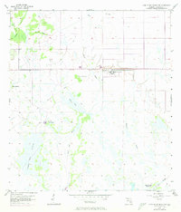
1957 Map of Long Island Marsh NW
USGS Topo · Published 1973About this map
Sheep Pen Marsh dominates this landscape of the Florida interior during the mid-twentieth century, showcasing a complex network of seasonal waterways and wetlands. The intricate drainage patterns are defined by features such as Tiger Bay Slough, Slippery Slough, and Honey Run. Human infrastructure is sparse but notable, centered around the large State Hospital facility and the nearby Pumphouse. A prominent Old Grade cuts across the terrain, likely tracing a former railroad or timber path that once connected these remote reaches. Small pockets of higher ground, identified as hammocks, provide distinct ecological and navigational landmarks, including Turkey Hammock and Sour Orange Hammock. To the northwest, the Parker Ranch represents the cattle-ranching heritage of DeSoto County, while elevated areas like Fourmile Island rise above the surrounding sloughs and gullies.
Find a feature on this map
14 named features on this map. Tap any name to fly to it.
Don’t see what you’re looking for? This feature index may not catch every label — zoom into the map to look around manually.
Map Details
Editions of this 1957 Long Island Marsh NW Map
3 editions found
Other maps of this area

1953 · Crewsville SE
USGS Topo · 1:24,000

1956 · Gardner
USGS Topo · 1:24,000

1956 · Arcadia SE
USGS Topo · 1:24,000

1956 · Crewsville SW
USGS Topo · 1:24,000

1956 · Long Island Marsh SW
USGS Topo · 1:24,000

1956 · Fort Pierce
USGS Topo · 1:250,000

1957 · Long Island Marsh NW
USGS Topo · 1:24,000

1957 · Long Island Marsh SE
USGS Topo · 1:24,000

1957 · Arcadia
USGS Topo · 1:24,000

1957 · Long Island Marsh NE
USGS Topo · 1:24,000