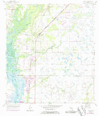
1956 Map of Ft. Ogden
USGS Topo · Published 1987About this map
The Peace River dominates the western half of this Florida landscape, winding southward toward Whidden Bay. The Seaboard Coast Line railroad cuts diagonally across the terrain, serving the interior settlements of Hull and Ft Ogden. This mid-century survey illustrates the rural character of the region before significant coastal expansion, showing clusters of community life at the Ft Ogden Cem and the nearby Ft Winder Ch. In the southern reaches, newer developments like Peace River Shores appear alongside older named locales such as Morgantown and Glen. The map captures a detailed hydrographic network including Hancock Lake, Lettuce Lake, and the braided channels of Hunters Creek, illustrating the complex water systems that defined life and transport in this part of DeSoto and Charlotte counties.
Find a feature on this map
30 named features on this map. Tap any name to fly to it.
Don’t see what you’re looking for? This feature index may not catch every label — zoom into the map to look around manually.
Map Details
Editions of this 1956 Ft. Ogden Map
4 editions found
Other maps of this area

1956 · Arcadia SE
USGS Topo · 1:24,000

1956 · Murdock SE
USGS Topo · 1:24,000

1956 · Murdock NE
USGS Topo · 1:24,000

1956 · Cleveland
USGS Topo · 1:24,000

1956 · Ft. Ogden
USGS Topo · 1:24,000

1956 · Nocatee
USGS Topo · 1:24,000

1956 · Bermont
USGS Topo · 1:24,000

1956 · West Palm Beach
USGS Topo · 1:250,000

1956 · Tampa
USGS Topo · 1:250,000

1956 · Fort Pierce
USGS Topo · 1:250,000