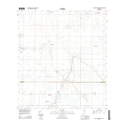
2015 Map of Long Island Marsh SW
USGS Topo · Published 2015About this map
Sparkman occupies the southern reaches of this landscape, situated just south of the Desoto Co Charlotte Co line. This 2015 survey reveals a complex network of wetlands and drainage patterns characteristic of the Florida interior. A series of sloughs and lakes dominate the terrain, including Myrtle Slough in the northwest and Tiger Bay Slough cutting through the center. The northeastern corner contains interesting named water bodies such as Sour Orange Lake, Lake Operation, and Cow Slough, which transition into the broad basin of Tippen Bay. The primary arterial connection for this rural area is SE Farabee Rd, which provides access across the county boundary. These hydrological features like Prairie Cr indicate a seasonal landscape where water flow and land management are critical to the local geography.
Find a feature on this map
21 named features on this map. Tap any name to fly to it.
Don’t see what you’re looking for? This feature index may not catch every label — zoom into the map to look around manually.
Map Details
Editions of this 2015 Long Island Marsh SW Map
This is the sole edition of this map. No revisions or reprints were ever made.
Other maps of this area

1956 · Arcadia SE
USGS Topo · 1:24,000

1956 · Telegraph Swamp NE
USGS Topo · 1:24,000

1956 · Telegraph Swamp NW
USGS Topo · 1:24,000

1956 · Long Island Marsh SW
USGS Topo · 1:24,000

1956 · Bermont
USGS Topo · 1:24,000

1956 · West Palm Beach
USGS Topo · 1:250,000

1956 · Fort Pierce
USGS Topo · 1:250,000

1957 · West Palm Beach
USGS Topo · 1:250,000

1957 · Long Island Marsh NW
USGS Topo · 1:24,000

1957 · Long Island Marsh SE
USGS Topo · 1:24,000