
1956 Map of Telegraph Swamp NE
USGS Topo · Published 1957About this map
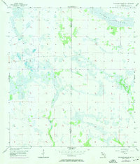
Rainey Slough dominates the northeastern landscape of this mid-century topographic study, illustrating the complex water drainage patterns of the South Florida interior. This 1956 planetable survey details a predominantly uninhabited wetland environment defined by numerous small ponds and cypress strands at the border of Charlotte Co and Glades Co. The map records a specific moment in the hydrological history of the region before significant modern drainage alterations, capturing the natural path of the Branch and the surrounding marshland. The terrain is notably flat, with elevations barely shifting more than a few feet across the sections, reflecting the characteristic low-lying geography that once defined much of the Caloosahatchee River watershed area.
Find a feature on this map
3 named features on this map. Tap any name to fly to it.
Don’t see what you’re looking for? This feature index may not catch every label — zoom into the map to look around manually.
Map Details
Editions of this 1956 Telegraph Swamp NE Map
2 editions found
Other maps of this area

1956 · Telegraph Swamp
USGS Topo · 1:24,000

1956 · Telegraph Swamp NW
USGS Topo · 1:24,000

1956 · Long Island Marsh SW
USGS Topo · 1:24,000

1956 · West Palm Beach
USGS Topo · 1:250,000

1956 · Fort Pierce
USGS Topo · 1:250,000

1957 · West Palm Beach
USGS Topo · 1:250,000

1957 · Long Island Marsh SE
USGS Topo · 1:24,000

1957 · Venus SW
USGS Topo · 1:24,000

1957 · Telegraph Swamp SE
USGS Topo · 1:24,000

1958 · Fort Pierce
USGS Topo · 1:250,000