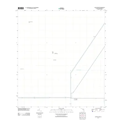
2012 Map of Long Island
USGS Topo · Published 2012About this map
John Buck Seminole Village and Little Doctor Seminole Village stand as distinct cultural markers in this 2012 survey of the Florida Everglades. The landscape is defined by the rigid management of water through a network of infrastructure, including Levee 67A, Levee 67, and the Agricultural Canal. These features illustrate the complex relationship between human habitation and the wetland environment in Miami-Dade County. Small elevated landforms like Palm Tree Head and the namesake Long Island provide the only natural topographic relief amidst the canals and levees. The presence of Sam Willies Camp and William McKinley Osceola Seminole Village further highlights the specific cultural history and continued presence of Indigenous communities within this managed ecosystem near the Blue Shanty Canal.
Find a feature on this map
12 named features on this map. Tap any name to fly to it.
Don’t see what you’re looking for? This feature index may not catch every label — zoom into the map to look around manually.
Map Details
Editions of this 2012 Long Island Map
This is the sole edition of this map. No revisions or reprints were ever made.
Other maps of this area

1956 · Miami
USGS Topo · 1:250,000

1958 · Miami
USGS Topo · 1:250,000

1972 · Shark Valley Lookout Tower
USGS Topo · 1:24,000

1972 · Chekika Island
USGS Topo · 1:24,000

1972 · South Of Coopertown
USGS Topo · 1:24,000

1973 · Fortymile Bend
USGS Topo · 1:24,000

1973 · Custard Apple Hammock
USGS Topo · 1:24,000

1973 · West Of Pennsuco
USGS Topo · 1:24,000

1973 · Long Island
USGS Topo · 1:24,000
1973 · Coopertown
USGS Topo · 1:24,000