1972 Map of South Of Coopertown
USGS Topo · Published 1976About this map
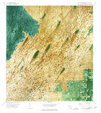
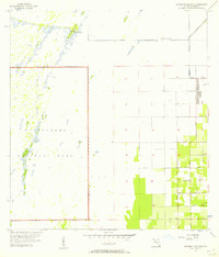
Blue Shanty Canal cuts through the western portion of this 1970s orthophotomap, illustrating the water management infrastructure that characterizes the Everglades landscape south of Coopertown. Unlike standard topographic maps, this edition utilizes aerial photography to depict the intricate textures of sawgrass areas and wetlands where traditional contours were omitted. Human encroachment into the glades is visible along the southern edge, where structured grid patterns and Howard Drive meet the wilder terrain. Notable landmarks are few in this transition zone, save for an Airboat Trail winding through the marsh and a lone Radio Tower standing near the agricultural boundary, marking the intersection of natural wetlands and suburban development.
Find a feature on this map
4 named features on this map. Tap any name to fly to it.
Don’t see what you’re looking for? This feature index may not catch every label — zoom into the map to look around manually.
Map Details
Editions of this 1972 South Of Coopertown Map
2 editions found

Other maps of this area

1949 · South Miami NW
USGS Topo · 1:24,000
1949 · Goulds
USGS Topo · 1:24,000
1955 · South Miami NW
USGS Topo · 1:24,000
1956 · Goulds
USGS Topo · 1:24,000
1956 · Grossman Hammock
USGS Topo · 1:24,000

1956 · Miami
USGS Topo · 1:250,000

1958 · Miami
USGS Topo · 1:250,000

1972 · Chekika Island
USGS Topo · 1:24,000

1972 · Black Hammock
USGS Topo · 1:24,000

1973 · Long Island
USGS Topo · 1:24,000