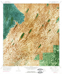
1972 Map of South Of Coopertown
USGS Topo · Published 1976About this map
The Blue Shanty Canal defines the western edge of this orthophotomap, cutting a straight line through the wetlands and sawgrass of the Florida Everglades. Captured in the early 1970s, the imagery reveals the delicate texture of the landscape, where tree islands stand out against the expanse of water and grass. Access through this terrain is limited to specialized transport, evidenced by the presence of an Airboat Trail winding through the marshes. In the southeastern corner, the transition toward development is visible along Howard Drive, where a regular grid of land plots begins to encroach upon the natural environment. A solitary Radio Tower serves as a prominent landmark in this emerging interface between the wild Everglades and the expanding outskirts of Dade County.
Find a feature on this map
4 named features on this map. Tap any name to fly to it.
Don’t see what you’re looking for? This feature index may not catch every label — zoom into the map to look around manually.
Map Details
Editions of this 1972 South Of Coopertown Map
2 editions found
Other maps of this area

1949 · South Miami NW
USGS Topo · 1:24,000

1949 · Goulds
USGS Topo · 1:24,000

1955 · South Miami NW
USGS Topo · 1:24,000

1956 · Goulds
USGS Topo · 1:24,000

1956 · Grossman Hammock
USGS Topo · 1:24,000

1956 · Miami
USGS Topo · 1:250,000

1958 · Miami
USGS Topo · 1:250,000

1972 · Chekika Island
USGS Topo · 1:24,000

1972 · South Of Coopertown
USGS Topo · 1:24,000
1972 · Black Hammock
USGS Topo · 1:24,000