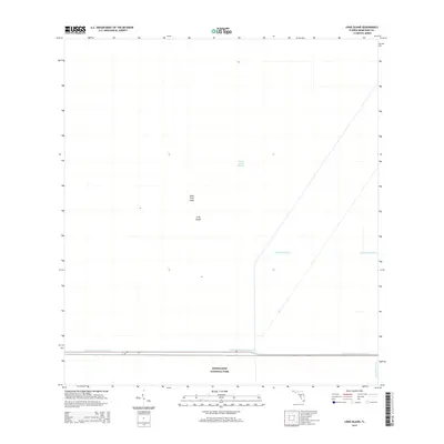
2015 Map of Long Island
USGS Topo · Published 2015About this map
Everglades National Park encompasses the southern expanse of this landscape, where the seasonal waters of the Shark River Slough define the ecosystem's character. Small hammocks and higher ground such as Palm Tree Head and Long Island appear as distinct landmarks within the freshwater marsh. Human management of this subtropical environment is visible through a network of waterways that border and intersect the natural drainage, including the Tamiami Canal Number C-4 running along the southern boundary and the straight lines of the Agricultural Canal and Blue Shanty Canal. These features illustrate the 21st-century efforts to balance regional water control with the preservation of the sawgrass prairies and sloughs that constitute this unique Florida terrain.
Find a feature on this map
7 named features on this map. Tap any name to fly to it.
Don’t see what you’re looking for? This feature index may not catch every label — zoom into the map to look around manually.
Map Details
Editions of this 2015 Long Island Map
This is the sole edition of this map. No revisions or reprints were ever made.
Other maps of this area

1956 · Miami
USGS Topo · 1:250,000

1958 · Miami
USGS Topo · 1:250,000

1972 · Shark Valley Lookout Tower
USGS Topo · 1:24,000

1972 · Chekika Island
USGS Topo · 1:24,000

1972 · South Of Coopertown
USGS Topo · 1:24,000

1973 · Fortymile Bend
USGS Topo · 1:24,000

1973 · Custard Apple Hammock
USGS Topo · 1:24,000

1973 · West Of Pennsuco
USGS Topo · 1:24,000

1973 · Long Island
USGS Topo · 1:24,000
1973 · Coopertown
USGS Topo · 1:24,000