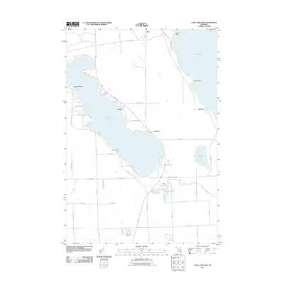
2011 Map of Long Lake East
USGS Topo · Published 2011About this map
Lake Huron's rugged coastline meets a chain of inland waters in this survey of northeast Michigan. The map centers on the massive expanse of Long Lake, where residential development and recreational routes like Long Lake Park Rd and Lakewood Dr surround established settlements at Ashland and Lakewood. Along the eastern shore of Lake Huron, notable landforms such as Bolton Point, Ferron Point, and the industrial site at Rockport define the transition between the Great Lake and the interior timberlands. To the south, smaller water bodies including Middle Lake and the winding Devils Lake create a complex marshy network fed by Long Lake Creek. The inclusion of the Silver City Airpark and the northern settlement of Bell illustrates the varied land use of Presque Isle Township, from quiet lakeside clusters to aviation and shipping points.
Find a feature on this map
60 named features on this map. Tap any name to fly to it.
Don’t see what you’re looking for? This feature index may not catch every label — zoom into the map to look around manually.
Map Details
Editions of this 2011 Long Lake East Map
This is the sole edition of this map. No revisions or reprints were ever made.
Other maps of this area

1954 · Alpena
USGS Topo · 1:250,000

1957 · Alpena
USGS Topo · 1:250,000

1958 · Alpena
USGS Topo · 1:250,000

1969 · Alpena
USGS Topo · 1:250,000

1971 · Lake Winyah
USGS Topo · 1:24,000
1971 · Presque Isle
USGS Topo · 1:24,000

1971 · Long Lake West
USGS Topo · 1:24,000

1971 · Alpena
USGS Topo · 1:24,000
1971 · Thompsons Harbor
USGS Topo · 1:24,000

1971 · Middle Island
USGS Topo · 1:24,000