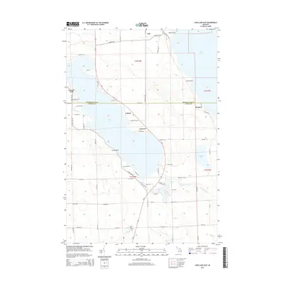
2014 Map of Long Lake East
USGS Topo · Published 2014About this map
Long Lake dominates the central landscape of this Presque Isle and Alpena County border region, where the interior woodlands meet the limestone-rich shores of Lake Huron. Small lakeside settlements like Ashland, Lakewood, and Breezy Point cluster along the eastern and western banks, reflecting a community deeply tied to the water. To the east, the shoreline is defined by Ferron Point and the site of Rockport, situated near the rugged coastal shelf. The northern reaches show the hamlet of Bell near Bolton Point, tucked away from the more developed southern tracts. A mix of seasonal and year-round roads, such as Co Line Hwy and Rockport Rd, weave together these coastal landings with inland features like the Silver City Airpark. The presence of several smaller water bodies, including Middle Lake and Devils Lake, highlights the complex glacial drainage pattern of the Northeast Michigan shoreline.
Find a feature on this map
70 named features on this map. Tap any name to fly to it.
Don’t see what you’re looking for? This feature index may not catch every label — zoom into the map to look around manually.
Map Details
Editions of this 2014 Long Lake East Map
This is the sole edition of this map. No revisions or reprints were ever made.
Other maps of this area

1954 · Alpena
USGS Topo · 1:250,000

1957 · Alpena
USGS Topo · 1:250,000

1958 · Alpena
USGS Topo · 1:250,000

1969 · Alpena
USGS Topo · 1:250,000

1971 · Lake Winyah
USGS Topo · 1:24,000
1971 · Presque Isle
USGS Topo · 1:24,000

1971 · Long Lake West
USGS Topo · 1:24,000

1971 · Alpena
USGS Topo · 1:24,000
1971 · Thompsons Harbor
USGS Topo · 1:24,000

1971 · Middle Island
USGS Topo · 1:24,000