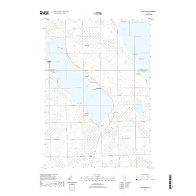
2019 Map of Long Lake East
USGS Topo · Published 2019About this map
Long Lake dominates this northern Michigan landscape, where the boundary between Presque Isle and Alpena counties cuts directly across the water. The eastern shore is characterized by a mix of established residential pockets and natural points, including the small community of Lakewood and the prominent Breezy Point. Towards the southern end of the sheet, the Silver City Airpark provides a modern transportation link to this lake-centered region.
Find a feature on this map
64 named features on this map. Tap any name to fly to it.
Don’t see what you’re looking for? This feature index may not catch every label — zoom into the map to look around manually.
Map Details
Editions of this 2019 Long Lake East Map
This is the sole edition of this map. No revisions or reprints were ever made.
Other maps of this area

1954 · Alpena
USGS Topo · 1:250,000

1957 · Alpena
USGS Topo · 1:250,000

1958 · Alpena
USGS Topo · 1:250,000

1969 · Alpena
USGS Topo · 1:250,000

1971 · Lake Winyah
USGS Topo · 1:24,000
1971 · Presque Isle
USGS Topo · 1:24,000

1971 · Long Lake West
USGS Topo · 1:24,000

1971 · Alpena
USGS Topo · 1:24,000
1971 · Thompsons Harbor
USGS Topo · 1:24,000

1971 · Middle Island
USGS Topo · 1:24,000