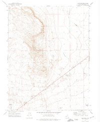
1972 Map of Long Ridge
USGS Topo · Published 1974About this map
Long Ridge dominates this Millard County landscape, a prominent geological spine that dictates the drainage patterns and land use in the early 1970s. The area is defined by its water management systems, crucial for sustaining life and livestock in the arid Utah basin. Numerous man-made catchments like Styler Reservoir, Deseret Reservoir, and Construction Reservoir are distributed across the terrain, alongside more specialized points like Highway Well and the Pony Express Reservoir. Evidence of human activity and resource exploration is visible through multiple Prospects and Borrow Pits scattered near the ridge. To the southeast, the geography transitions toward the basin floor, marked by the numbering of Sevier Lake Res No 5 and Sevier Lake Res No 6. This map illustrates the intersection of natural desert topography and the infrastructure required to manage seasonal runoff from ephemeral channels like Soap Wash.
Find a feature on this map
13 named features on this map. Tap any name to fly to it.
Don’t see what you’re looking for? This feature index may not catch every label — zoom into the map to look around manually.
Map Details
Editions of this 1972 Long Ridge Map
This is the sole edition of this map. No revisions or reprints were ever made.
Other maps of this area

1885 · Sevier Desert
USGS Topo · 1:250,000

1908 · Fish Springs
USGS Topo · 1:250,000

1910 · Fish Springs
USGS Topo · 1:250,000

1953 · Delta
USGS Topo · 1:250,000

1958 · Delta
USGS Topo · 1:250,000

1962 · Delta
USGS Topo · 1:250,000

1971 · Red Pass
USGS Topo · 1:24,000

1971 · Clay Knoll
USGS Topo · 1:24,000

1971 · Rocky Knoll
USGS Topo · 1:24,000

1972 · Whirlwind Valley SW
USGS Topo · 1:24,000