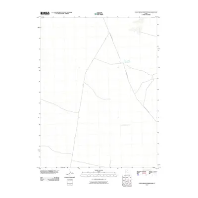
2010 Map of Long Ridge Reservoir
USGS Topo · Published 2010About this map
Long Ridge Reservoir serves as the central landmark in this high-desert portion of Millard County, Utah. The landscape is defined by its sparse infrastructure, primarily consisting of a remote road network tailored for resource management and ranching access. Two primary arteries, 3C Rd and Long Ridge Reservoir Rd, intersect in the northern section of the map, providing a glimpse into the logistical layout of this arid basin during the early 21st century. The survey illustrates the stark, open character of the region, where water management features like the reservoir are critical focal points for local land use and transit.
Find a feature on this map
3 named features on this map. Tap any name to fly to it.
Don’t see what you’re looking for? This feature index may not catch every label — zoom into the map to look around manually.
Map Details
Editions of this 2010 Long Ridge Reservoir Map
This is the sole edition of this map. No revisions or reprints were ever made.
Other maps of this area

1908 · Fish Springs
USGS Topo · 1:250,000

1910 · Fish Springs
USGS Topo · 1:250,000

1953 · Delta
USGS Topo · 1:250,000

1958 · Delta
USGS Topo · 1:250,000

1960 · Notch Peak
USGS Topo · 1:62,500

1962 · Delta
USGS Topo · 1:250,000

1972 · Whirlwind Valley SW
USGS Topo · 1:24,000
1972 · Long Ridge
USGS Topo · 1:24,000

1972 · Long Ridge Reservoir
USGS Topo · 1:24,000
1972 · Marjum Pass
USGS Topo · 1:24,000