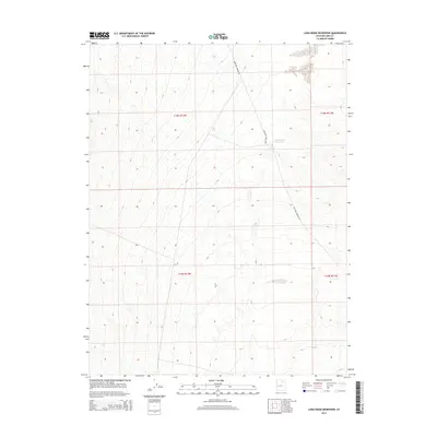
2014 Map of Long Ridge Reservoir
USGS Topo · Published 2014About this map
Long Ridge Reservoir sits at the center of this Millard County landscape, a vital water catchment in an arid interior basin. The topography is defined by the steady descent of the terrain toward the east, where the reservoir collects runoff from the surrounding slopes. The primary corridor through this remote section of the Great Basin is Antelope Springs Rd, which snakes north to south along the 5,000-foot contour line. This 2014 survey documents the public land survey system grid across townships t18s r12w, t18s r11w, t19s r12w, and t19s r11w, illustrating the precise sectioning of the Utah territory for land management and resource use.
Find a feature on this map
6 named features on this map. Tap any name to fly to it.
Don’t see what you’re looking for? This feature index may not catch every label — zoom into the map to look around manually.
Map Details
Editions of this 2014 Long Ridge Reservoir Map
This is the sole edition of this map. No revisions or reprints were ever made.
Other maps of this area

1908 · Fish Springs
USGS Topo · 1:250,000

1910 · Fish Springs
USGS Topo · 1:250,000

1953 · Delta
USGS Topo · 1:250,000

1958 · Delta
USGS Topo · 1:250,000

1960 · Notch Peak
USGS Topo · 1:62,500

1962 · Delta
USGS Topo · 1:250,000

1972 · Whirlwind Valley SW
USGS Topo · 1:24,000
1972 · Long Ridge
USGS Topo · 1:24,000

1972 · Long Ridge Reservoir
USGS Topo · 1:24,000
1972 · Marjum Pass
USGS Topo · 1:24,000