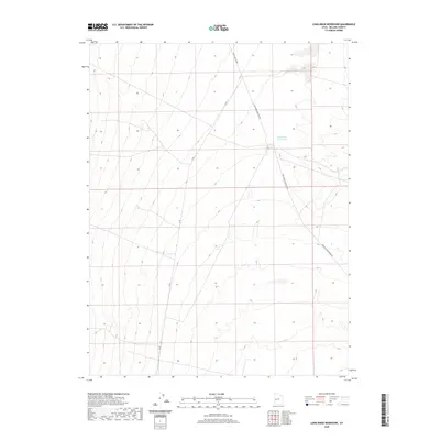
2020 Map of Long Ridge Reservoir
USGS Topo · Published 2020About this map
Long Ridge Reservoir sits at the center of this Millard County landscape, serving as a primary water management feature in an area defined by wide elevation contours and a structured grid of sections. The terrain is marked by the presence of Death Canyon Rd, which cuts through the northern sections, indicating the historical routes through the arid Utah desert. This 2020 study highlights the sparse infrastructure characteristic of the region, where land management and water access remain the defining elements of human activity. The map provides a clear look at the public land survey system, illustrating the deliberate partitioning of the basin for resource allocation and grazing.
Find a feature on this map
2 named features on this map. Tap any name to fly to it.
Don’t see what you’re looking for? This feature index may not catch every label — zoom into the map to look around manually.
Map Details
Editions of this 2020 Long Ridge Reservoir Map
This is the sole edition of this map. No revisions or reprints were ever made.
Other maps of this area

1908 · Fish Springs
USGS Topo · 1:250,000

1910 · Fish Springs
USGS Topo · 1:250,000

1953 · Delta
USGS Topo · 1:250,000

1958 · Delta
USGS Topo · 1:250,000

1960 · Notch Peak
USGS Topo · 1:62,500

1962 · Delta
USGS Topo · 1:250,000

1972 · Whirlwind Valley SW
USGS Topo · 1:24,000
1972 · Long Ridge
USGS Topo · 1:24,000

1972 · Long Ridge Reservoir
USGS Topo · 1:24,000
1972 · Marjum Pass
USGS Topo · 1:24,000