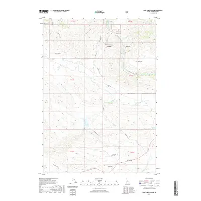
2020 Map of Long Tom Reservoir
USGS Topo · Published 2020About this map
The Boise National Forest covers much of this high-altitude landscape in Elmore County, dominated by the sharp elevation changes of the Danskin Mountains and Danskin Ridge SE. Centrally located, the Long Tom Reservoir sits at the confluence of several mountain drainages, including Long Tom Creek and West Fork Long Tom Creek. The map documents a complex network of historic and modern routes, from the NE Immigrant Rd in the southwest to the Long Tom (Dixie Cutoff) trail. This area highlights the transition from managed forest lands to open grazing areas like Little Sage Hen Flat and Sproule Flat, which are interspersed with vital water sources such as Montrose Spring and Berneathy Spring. The South Fork Boise River cuts through the northern sections, creating a steep canyon environment near Indian Point.
Find a feature on this map
39 named features on this map. Tap any name to fly to it.
Don’t see what you’re looking for? This feature index may not catch every label — zoom into the map to look around manually.
Map Details
Editions of this 2020 Long Tom Reservoir Map
This is the sole edition of this map. No revisions or reprints were ever made.
Other maps of this area

1892 · Mountain Home
USGS Topo · 1:125,000

1892 · Camas Prairie
USGS Topo · 1:125,000

1893 · Mountain Home
USGS Topo · 1:125,000

1893 · Camas Prairie
USGS Topo · 1:125,000

1955 · Hailey
USGS Topo · 1:250,000

1956 · Mountain Home North
USGS Topo · 1:24,000

1956 · Mountain Home
USGS Topo · 1:62,500
1958 · Bennett Mtn
USGS Topo · 1:62,500

1959 · Hailey
USGS Topo · 1:250,000

1960 · Danskin Peak
USGS Topo · 1:62,500