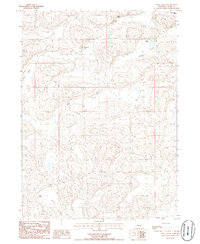
1986 Map of Long Valley
USGS Topo · Published 1986About this map
Merrihew Ranch and several other family-held homesteads define the high plains landscape of Grant County during the mid-1980s. This survey of the Nebraska Sandhills reveals a pattern of isolated ranching operations connected by unimproved roads and trails across a series of parallel depressions including Long Valley and Anderson Valley. The presence of the Landing Strip near Bob Merrihew Ranch underscores the reliance on small-scale aviation for navigating this expansive terrain. Further south, the Lowe Ranch sits near the head of Gross Valley, illustrating how early settlers utilized the natural drainage basins for livestock and shelter. For genealogists and land historians, these specific ranch labels provide a precise record of late-20th-century land tenure in a region where few other landmarks exist, from the Burgess Ranch to the Minor-Adams Ranch on the eastern edge of the quadrangle.
Find a feature on this map
11 named features on this map. Tap any name to fly to it.
Don’t see what you’re looking for? This feature index may not catch every label — zoom into the map to look around manually.
Map Details
Editions of this 1986 Long Valley Map
This is the sole edition of this map. No revisions or reprints were ever made.
Other maps of this area

1948 · George Lake
USGS Topo · 1:62,500

1949 · Rackett
USGS Topo · 1:62,500

1950 · Velma
USGS Topo · 1:62,500

1950 · George Lake
USGS Topo · 1:62,500

1950 · Longfellow Lake
USGS Topo · 1:62,500

1951 · Rackett
USGS Topo · 1:62,500

1954 · Scottsbluff
USGS Topo · 1:250,000

1954 · North Platte
USGS Topo · 1:250,000

1956 · North Platte
USGS Topo · 1:250,000

1957 · North Platte
USGS Topo · 1:250,000