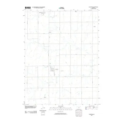
2009 Map of Longford
USGS Topo · Published 2009About this map
Longford and Oak Hill anchor this section of Clay County, reflecting a typical Kansas prairie grid of the early twenty-first century. The landscape is defined by the winding paths of Chapman Creek and its tributary, West Chapman Creek, which break the regularity of the section-line roads. For genealogists and local historians, several rural burial grounds are documented across the township, including Swartwood Cemetery in the south and Pleasant Valley Cemetery in the northeast. The residential layout of Longford is detailed with specific streets such as Santfe Ave, Main St, and Cottonwood Rd, showing the concentrated settlement pattern amidst a wide-reaching agricultural network. Additional watercourses like Badger Creek and Basket Creek further delineate the local drainage and topography in this pastoral region.
Find a feature on this map
32 named features on this map. Tap any name to fly to it.
Don’t see what you’re looking for? This feature index may not catch every label — zoom into the map to look around manually.
Map Details
Editions of this 2009 Longford Map
This is the sole edition of this map. No revisions or reprints were ever made.
Other maps of this area

1891 · Clay Center
USGS Topo · 1:125,000

1955 · Manhattan
USGS Topo · 1:250,000

1956 · Manhattan
USGS Topo · 1:250,000

1957 · Manhattan
USGS Topo · 1:250,000
1964 · Industry
USGS Topo · 1:24,000
1964 · Buckeye
USGS Topo · 1:24,000

1964 · Clay Center SW
USGS Topo · 1:24,000

1964 · Idana
USGS Topo · 1:24,000

1964 · Miltonvale
USGS Topo · 1:24,000
1965 · Manchester NW
USGS Topo · 1:24,000