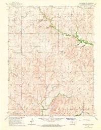
1965 Map of Manchester NW
USGS Topo · Published 1966About this map
West Chapman Creek meanders across the northern portion of this Kansas landscape, reflecting the rural agricultural character of Ottawa and Clay counties during the mid-1960s. The terrain is defined by a series of townships including Sherman, Chapman, Grant, and Durham, where small rural institutions provided the social fabric for farming families. Local landmarks like Bethany Ch, Mt Liberty Ch, and the Union Sch are clearly marked, alongside evidence of local industry such as a Quarry. Transportation in the southern reaches is dominated by the Atchison Topeka and Santa Fe railroad, which cuts through Richland and Ottawa townships. This survey was conducted as part of the Department of the Interior program for the development of the Missouri River Basin, capturing the region's drainage patterns through systems like Coal Creek and Sun Valley Ch.
Find a feature on this map
15 named features on this map. Tap any name to fly to it.
Don’t see what you’re looking for? This feature index may not catch every label — zoom into the map to look around manually.
Map Details
Editions of this 1965 Manchester NW Map
This is the sole edition of this map. No revisions or reprints were ever made.
Other maps of this area

1891 · Clay Center
USGS Topo · 1:125,000

1892 · Minneapolis
USGS Topo · 1:125,000

1955 · Manhattan
USGS Topo · 1:250,000

1956 · Manhattan
USGS Topo · 1:250,000

1957 · Manhattan
USGS Topo · 1:250,000

1964 · Lamar
USGS Topo · 1:24,000

1964 · Idana
USGS Topo · 1:24,000

1964 · Miltonvale
USGS Topo · 1:24,000
1965 · Vine Creek
USGS Topo · 1:24,000
1965 · Wells
USGS Topo · 1:24,000