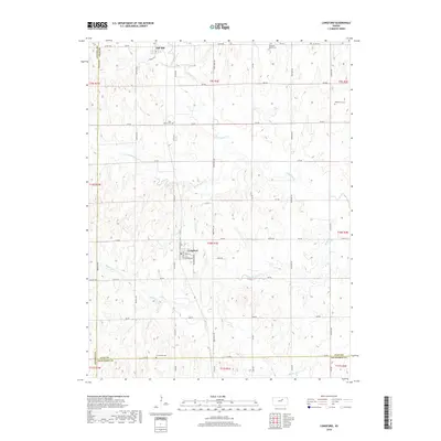
2018 Map of Longford
USGS Topo · Published 2018About this map
The settlement of Longford serves as a focal point in this section of Clay County, situated where Weda St meets Neighbor Rd. The surrounding agricultural landscape is defined by the drainage basins of Chapman Cr and W Chapman Cr, which create a rolling topography dissected by a precise grid of rural section roads. To the north, the community of Oak Hill sits near the county line, while the southern boundary marks the transition from Clay into Dickinson County.
Find a feature on this map
37 named features on this map. Tap any name to fly to it.
Don’t see what you’re looking for? This feature index may not catch every label — zoom into the map to look around manually.
Map Details
Editions of this 2018 Longford Map
This is the sole edition of this map. No revisions or reprints were ever made.
Other maps of this area

1891 · Clay Center
USGS Topo · 1:125,000

1955 · Manhattan
USGS Topo · 1:250,000

1956 · Manhattan
USGS Topo · 1:250,000

1957 · Manhattan
USGS Topo · 1:250,000
1964 · Industry
USGS Topo · 1:24,000
1964 · Buckeye
USGS Topo · 1:24,000

1964 · Clay Center SW
USGS Topo · 1:24,000

1964 · Idana
USGS Topo · 1:24,000

1964 · Miltonvale
USGS Topo · 1:24,000
1965 · Manchester NW
USGS Topo · 1:24,000