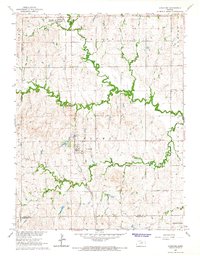
1965 Map of Longford
USGS Topo · Published 1966About this map
Longford serves as a central hub for this portion of the Kansas prairie, where the Atchison Topeka and Santa Fe railway provides the primary corridor for movement and commerce. The landscape is defined by the winding paths of Chapman Creek and its tributaries, including West Chapman Creek and Badger Creek, which carve through the townships of Oakland, Chapman, and Flora. The density of rural infrastructure during this mid-century period is evident in the scattered locations of local landmarks such as Walker Sch and Wesley Chapel. Genealogists will find significant value in the distribution of community burial grounds, including Swartwood Cem, Pleasant Valley Cem, Wesleyan Cem, and Rose Meron Cem, which mark the historical footprint of early families across the Clay, Ottawa, and Dickinson County lines. In the northern section, Oak Hill persists as a notable settlement along the rail line, maintaining its own post office during this era of topographic mapping.
Find a feature on this map
26 named features on this map. Tap any name to fly to it.
Don’t see what you’re looking for? This feature index may not catch every label — zoom into the map to look around manually.
Map Details
Editions of this 1965 Longford Map
This is the sole edition of this map. No revisions or reprints were ever made.
Other maps of this area

1891 · Clay Center
USGS Topo · 1:125,000

1955 · Manhattan
USGS Topo · 1:250,000

1956 · Manhattan
USGS Topo · 1:250,000

1957 · Manhattan
USGS Topo · 1:250,000
1964 · Industry
USGS Topo · 1:24,000
1964 · Buckeye
USGS Topo · 1:24,000

1964 · Clay Center SW
USGS Topo · 1:24,000

1964 · Idana
USGS Topo · 1:24,000

1964 · Miltonvale
USGS Topo · 1:24,000
1965 · Manchester NW
USGS Topo · 1:24,000