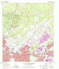
1967 Map of Longhorn
USGS Topo · Published 1986About this map
The San Antonio corporate boundary bisects this landscape, marking the northward expansion of the city into the surrounding Bexar County ranchlands. The settlement of Wetmore and the surrounding area exhibit a transition from rural homesteads to suburban developments like Windcrest, Hollywood Park, and Hill Country Village. This era of growth is underscored by the density of educational institutions, ranging from the historic Coker Sch to modern campuses like Douglas MacArthur High Sch and Theodore Roosevelt High Sch. Numerous small family and community burial grounds, including Classen Cem, Tampke Cem, and Beitel Memorial Cem, are preserved amidst the emerging residential grid.
Find a feature on this map
71 named features on this map. Tap any name to fly to it.
Don’t see what you’re looking for? This feature index may not catch every label — zoom into the map to look around manually.
Map Details
Editions of this 1967 Longhorn Map
4 editions found
Other maps of this area

1953 · Otis Ridge
USGS Topo · 1:24,000

1953 · Schertz
USGS Topo · 1:24,000

1953 · San Antonio West
USGS Topo · 1:24,000

1953 · Bulverde
USGS Topo · 1:24,000

1953 · San Antonio East
USGS Topo · 1:24,000

1953 · Bat Cave
USGS Topo · 1:24,000

1953 · Longhorn
USGS Topo · 1:24,000

1953 · Castle Hills
USGS Topo · 1:24,000

1953 · Martinez
USGS Topo · 1:24,000

1954 · San Antonio
USGS Topo · 1:250,000