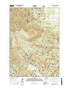
2017 Map of Lookout Mountain
USGS Topo · Published 2017About this map
Ochoco National Forest dominates this landscape in the Ochoco Mountains, where the high-altitude terrain is defined by a series of prominent peaks and expansive prairies. Resource extraction and recreation define the local geography, notably at the Independent Mine and Mother Lode Mine located on the western slopes of Lookout Mountain. These sites are linked by a network of forest roads and specialized trails like Snomobile #1 and Snomobile #4, reflecting the area's dual role as a working forest and a recreational destination.
Find a feature on this map
58 named features on this map. Tap any name to fly to it.
Don’t see what you’re looking for? This feature index may not catch every label — zoom into the map to look around manually.
Map Details
Editions of this 2017 Lookout Mountain Map
This is the sole edition of this map. No revisions or reprints were ever made.
Other maps of this area

1951 · Post
USGS Topo · 1:62,500

1951 · Lookout Mtn
USGS Topo · 1:62,500

1955 · Bend
USGS Topo · 1:250,000

1957 · Bend
USGS Topo · 1:250,000

1958 · Bend
USGS Topo · 1:250,000

1965 · Williams Prairie
USGS Topo · 1:24,000

1966 · Mt. Pisgah
USGS Topo · 1:24,000

1981 · Prineville
USGS Topo · 1:100,000
1983 · Committee Creek
USGS Topo · 1:24,000
1990 · Lookout Mountain
USGS Topo · 1:24,000