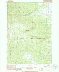
1990 Map of Lookout Mountain
USGS Topo · Published 1990About this map
Ochoco National Forest dominates this high-altitude landscape in central Oregon, where the rugged peaks of the Ochoco Mountains reach their height at Lookout Mountain. This 1990 provisional survey documents a landscape defined by its water sources and mining history, notably the Amity Mine and Independent Mine located in the northwest quadrant near Cline Creek. The map reveals a complex network of seasonal drainages and springs, such as Lookout Spring and Kemp Spring, which sustain the high-elevation meadows of Big Summit Prairie and Gray Prairie. The transition from dense forest to open grasslands like the Jungle and various mountain points provides a detailed look at the land management boundaries between public forest and private holdings. These elevation markers and named springs are vital for understanding the historical land use and hydrologic patterns of the region before modern developments.
Find a feature on this map
39 named features on this map. Tap any name to fly to it.
Don’t see what you’re looking for? This feature index may not catch every label — zoom into the map to look around manually.
Map Details
Editions of this 1990 Lookout Mountain Map
This is the sole edition of this map. No revisions or reprints were ever made.
Other maps of this area

1951 · Post
USGS Topo · 1:62,500

1951 · Lookout Mtn
USGS Topo · 1:62,500

1955 · Bend
USGS Topo · 1:250,000

1957 · Bend
USGS Topo · 1:250,000

1958 · Bend
USGS Topo · 1:250,000

1965 · Williams Prairie
USGS Topo · 1:24,000

1966 · Mt. Pisgah
USGS Topo · 1:24,000

1981 · Prineville
USGS Topo · 1:100,000
1983 · Committee Creek
USGS Topo · 1:24,000
1990 · Gerow Butte
USGS Topo · 1:24,000