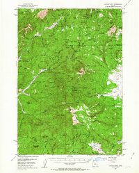
1951 Map of Lookout Mtn
USGS Topo · Published 1963About this map
Ochoco National Forest dominates this mid-century survey, revealing a landscape of heavy mining activity and high-elevation prairie in central Oregon. Small-scale operations such as the Ochoco Mine, Independent Mine, and Round Mtn Mine are scattered across the terrain, indicating the era's mineral prospecting. The mapping of the Ochoco Ranger Sta and various lookout points like Lookout Mountain and Lutsey Pt underscores the administrative focus on forest management and fire prevention during this period. Local history is preserved in the location of the Simpson Place and the Nelson Monument, while the presence of a Cem and Old Kelly Mill speaks to the early settlement and industrial efforts within the mountain's shadow. This area is characterized by a network of springs and flats, such as Corral Flat and Grant Meadows, which likely supported the local cattle ranching tradition, further evidenced by the Sheep Corrals noted near the Ochoco Butte.
Find a feature on this map
123 named features on this map. Tap any name to fly to it.
Don’t see what you’re looking for? This feature index may not catch every label — zoom into the map to look around manually.
Map Details
Editions of this 1951 Lookout Mtn Map
2 editions found
Other maps of this area

1926 · Mitchell
USGS Topo · 1:125,000

1946 · Eagle Rock
USGS Topo · 1:62,500

1948 · Eagle Rock
USGS Topo · 1:62,500

1948 · Ochoco Reservoir
USGS Topo · 1:62,500

1950 · Ochoco Reservoir
USGS Topo · 1:62,500

1951 · Post
USGS Topo · 1:62,500

1951 · Lookout Mtn
USGS Topo · 1:62,500

1955 · Bend
USGS Topo · 1:250,000

1957 · Bend
USGS Topo · 1:250,000

1958 · Bend
USGS Topo · 1:250,000