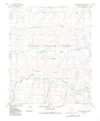
1984 Map of Lookout Ridge C-4
USGS Topo · Published 1985About this map
The National Petroleum Reserve in Alaska dominates this 1980s landscape on the North Slope, revealing a wilderness defined by its complex drainage patterns and ridgelines. The Meade River meanders across the southern portion of the sheet, joined by smaller tributaries like Kili Creek and the Kaksu River. This survey captures a moment when the region was primarily utilized for resource evaluation and subsistence, evidenced by the presence of a Tractor Trail winding through the northern hills. High ground is marked by prominent elevations such as Shaningarok Ridge and Kulugra Ridge, which separate the primary watersheds. The drainage of Shaningarok Creek cuts through the central valley, illustrating the characteristic topography of the Arctic tundra before modern infrastructure expansion.
Find a feature on this map
8 named features on this map. Tap any name to fly to it.
Don’t see what you’re looking for? This feature index may not catch every label — zoom into the map to look around manually.
Map Details
Editions of this 1984 Lookout Ridge C-4 Map
This is the sole edition of this map. No revisions or reprints were ever made.
Other maps of this area

1951 · Lookout Ridge
USGS Topo · 1:250,000

1956 · Lookout Ridge
USGS Topo · 1:250,000
1984 · Lookout Ridge D-5
USGS Topo · 1:63,360
1984 · Lookout Ridge D-4
USGS Topo · 1:63,360
1984 · Lookout Ridge C-5
USGS Topo · 1:63,360

1984 · Lookout Ridge D-3
USGS Topo · 1:63,360
1985 · Lookout Ridge B-5
USGS Topo · 1:63,360
1985 · Lookout Ridge C-3
USGS Topo · 1:63,360
1985 · Lookout Ridge B-4
USGS Topo · 1:63,360
1985 · Lookout Ridge B-3
USGS Topo · 1:63,360