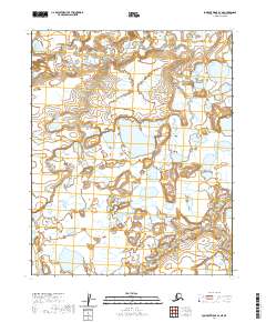
2020 Map of Lookout Ridge D-1 NE
USGS Topo · Published 2020About this map
Ispagluk River and its intricate northern tributaries define this arctic landscape within the North Slope Borough. This 2020 survey illustrates the complex drainage patterns of the Alaskan tundra, where seasonal watercourses like Ishuktak Cr carve through the low-lying terrain. The map provides a detailed view of the natural hydrology and wetland systems that characterize the region between the De Long and Endicott Mountains. These survey boundaries, including t7n r17w and t8n r17w, represent the foundational grid of the Public Land Survey System in one of the most northern reaches of the United States. The absence of human-made infrastructure emphasizes the preservation of this wilderness area as a purely topographical and hydrological study.
Find a feature on this map
7 named features on this map. Tap any name to fly to it.
Don’t see what you’re looking for? This feature index may not catch every label — zoom into the map to look around manually.
Map Details
Editions of this 2020 Lookout Ridge D-1 NE Map
This is the sole edition of this map. No revisions or reprints were ever made.
Other maps of this area

1951 · Meade River
USGS Topo · 1:250,000

1951 · Lookout Ridge
USGS Topo · 1:250,000

1951 · Teshekpuk
USGS Topo · 1:250,000

1951 · Ikpikpuk River
USGS Topo · 1:250,000

1955 · Teshekpuk
USGS Topo · 1:250,000
1955 · Teshekpuk A-5
USGS Topo · 1:63,360

1955 · Meade River
USGS Topo · 1:250,000
1955 · Meade River A-1
USGS Topo · 1:63,360

1956 · Lookout Ridge
USGS Topo · 1:250,000

1956 · Ikpikpuk River
USGS Topo · 1:250,000