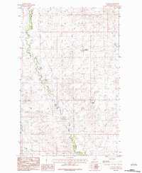
1983 Map of Lookout
USGS Topo · Published 1983About this map
The Fort Peck Indian Reservation Boundary defines the western edge of this landscape, marking the transition between tribal lands and the open range of Valley County. In this rugged corner of Montana, the winding course of Porcupine Creek serves as a central drainage, flanked by several smaller geographical features like Enright Coulee and Hay Coulee. Industry leaves a distinct mark near the center of the sheet with a labeled Strip Mine, indicating the mineral extraction activity that often occurred alongside cattle ranching in this era. Other scattered water resources, including Middle Reservoir and Potter Spring, appear as critical landmarks in an otherwise arid and sparsely populated expanse of the northern plains.
Find a feature on this map
9 named features on this map. Tap any name to fly to it.
Don’t see what you’re looking for? This feature index may not catch every label — zoom into the map to look around manually.
Map Details
Editions of this 1983 Lookout Map
This is the sole edition of this map. No revisions or reprints were ever made.
Other maps of this area

1918 · Porcupine Valley
USGS Topo · 1:62,500

1919 · Boundary
USGS Topo · 1:125,000

1943 · Glasgow
USGS Topo · 1:125,000

1954 · Glasgow
USGS Topo · 1:250,000

1957 · Glasgow
USGS Topo · 1:250,000

1958 · Glasgow
USGS Topo · 1:250,000

1969 · Chapman Coulee NE
USGS Topo · 1:24,000

1969 · Hawk Coulee
USGS Topo · 1:24,000

1973 · Baylor SE
USGS Topo · 1:24,000

1973 · Cameron Point
USGS Topo · 1:24,000