
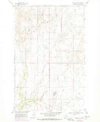
1969 Map of Hawk Coulee
USGS Topo · Published 1972About this map
Section School stands as a central landmark in this 1969 survey of Valley County, Montana, where the prairie landscape is defined by the sharp cuts of coulees and the utility of the Burlington Northern railroad. The line runs along the southern portion of the quadrangle, crossing the East Fork and skirting several Gravel Pit operations. The drainage patterns here are distinct, with Cherry Creek, Foss Coulee, and the namesake Hawk Coulee carving out the terrain toward the Missouri River Basin. Human activity is concentrated near the transit corridors, evidenced by the presence of a Drive-in Theater and multiple Sewage Disposal Ponds, reflecting the infrastructure and mid-century recreational habits of the surrounding rural community during the late 1960s.
Find a feature on this map
10 named features on this map. Tap any name to fly to it.
Don’t see what you’re looking for? This feature index may not catch every label — zoom into the map to look around manually.
Map Details
Editions of this 1969 Hawk Coulee Map
2 editions found
Other maps of this area

1914 · Nashua
USGS Topo · 1:62,500

1916 · Nashua
USGS Topo · 1:62,500

1918 · Porcupine Valley
USGS Topo · 1:62,500

1943 · Glasgow
USGS Topo · 1:125,000

1954 · Glasgow
USGS Topo · 1:250,000

1957 · Glasgow
USGS Topo · 1:250,000

1958 · Glasgow
USGS Topo · 1:250,000

1958 · Glasgow
USGS Topo · 1:24,000

1958 · Whately
USGS Topo · 1:24,000

1969 · Cornwell Reservoir
USGS Topo · 1:24,000