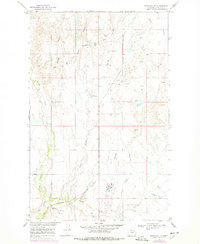
1969 Map of Hawk Coulee
USGS Topo · Published 1978About this map
Section School stands as a lonely institutional marker in this part of Valley County, where the landscape is defined by the complex drainage systems of Cherry Creek and Foss Coulee. The terrain is characterized by deep coulees and intermittent springs that dictated the placement of early infrastructure. Infrastructure development by the late 1960s is evidenced by the Burlington Northern railroad corridor and the presence of a Drive-in Theater near the southern boundary, suggesting a community hub serving the surrounding rural population. The map also documents utilitarian land use, including multiple Gravel Pit sites and Sewage Disposal Ponds. Tracing the paths of Hawk Coulee and its East Fork Hawk Coulee, one can see how the natural topography influenced the regional transit and settlement patterns in this portion of the Missouri River Basin.
Find a feature on this map
10 named features on this map. Tap any name to fly to it.
Don’t see what you’re looking for? This feature index may not catch every label — zoom into the map to look around manually.
Map Details
Editions of this 1969 Hawk Coulee Map
2 editions found

Other maps of this area

1914 · Nashua
USGS Topo · 1:62,500

1916 · Nashua
USGS Topo · 1:62,500

1918 · Porcupine Valley
USGS Topo · 1:62,500

1943 · Glasgow
USGS Topo · 1:125,000

1954 · Glasgow
USGS Topo · 1:250,000

1957 · Glasgow
USGS Topo · 1:250,000

1958 · Glasgow
USGS Topo · 1:250,000

1958 · Glasgow
USGS Topo · 1:24,000

1958 · Whately
USGS Topo · 1:24,000

1969 · Cornwell Reservoir
USGS Topo · 1:24,000