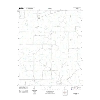
2012 Map of Looxahoma
USGS Topo · Published 2012About this map
The community of Looxahoma and the surrounding Tate County countryside are defined by a network of rural roads and numerous small family or community burial grounds. This 2012 survey illustrates the agricultural character of the region, where the natural drainage of Basket Cr and Senatobia Cr has been modified by the James Wolf Canal. For genealogists and local historians, the map is an exceptional resource for locating specific cemeteries, including Lewers Chapel Cem, Saint Maria Cem, and Fredonia Cem, which are scattered throughout the landscape. Notable landmarks such as the Glenville Lookout Tower near the intersection of Dandridge Rd and Mitchell Rd provide fixed points of reference in an area otherwise characterized by its creeks and small settlements like Crossroad and Barr.
Find a feature on this map
67 named features on this map. Tap any name to fly to it.
Don’t see what you’re looking for? This feature index may not catch every label — zoom into the map to look around manually.
Map Details
Editions of this 2012 Looxahoma Map
This is the sole edition of this map. No revisions or reprints were ever made.
Other maps of this area

1940 · Oxford
USGS Topo · 1:62,500

1943 · Oxford
USGS Topo · 1:62,500

1944 · Senatobia
USGS Topo · 1:62,500

1944 · Tyro
USGS Topo · 1:62,500

1952 · Sardis
USGS Topo · 1:62,500

1953 · Sardis
USGS Topo · 1:62,500

1956 · Tupelo
USGS Topo · 1:250,000

1958 · Tupelo
USGS Topo · 1:250,000

1971 · Wyatte
USGS Topo · 1:24,000
1971 · Tyro
USGS Topo · 1:24,000