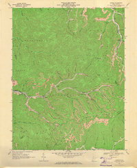
1968 Map of Lorado
USGS Topo · Published 1971About this map
The coal-mining heart of the West Virginia mountains is captured here during the late 1960s, a period when the extractive industry defined the geography of the Logan and Boone County lines. The Chesapeake and Ohio railroad corridor follows Buffalo Creek through a series of company towns and industrial sites, including Lundale, Craneco, and Lorado. The landscape is characterized by its steep, narrow valleys where every available level bench is utilized for rail spurs and coal infrastructure, as seen in the numerous Mine Dump and Mine labels scattered across the ridges. Higher elevations offer a different perspective, with the Spring Mountain Lookout Tower standing over the drainage divides of Pond Fork and Huff Creek. This survey provides a precise record of the early post-war industrial landscape, tracing the complex network of creeks and coal branches that linked remote settlements like Pardee and Saunders to the wider rail network.
Find a feature on this map
56 named features on this map. Tap any name to fly to it.
Don’t see what you’re looking for? This feature index may not catch every label — zoom into the map to look around manually.
Map Details
Editions of this 1968 Lorado Map
Other maps of this area

1891 · Oceana
USGS Topo · 1:125,000

1893 · Oceana
USGS Topo · 1:125,000

1898 · Oceana
USGS Topo · 1:125,000

1909 · Gilbert
USGS Topo · 1:48,000

1910 · Pineville
USGS Topo · 1:48,000

1910 · Bald Knob
USGS Topo · 1:48,000

1912 · Bald Knob
USGS Topo · 1:62,500

1912 · Gilbert
USGS Topo · 1:62,500

1912 · Pineville
USGS Topo · 1:62,500

1913 · Logan
USGS Topo · 1:62,500