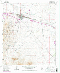
1963 Map of Lordsburg
USGS Topo · Published 1980About this map
Lordsburg serves as a critical desert junction where the Southern Pacific tracks and modern highway corridors intersect older paths of Western migration. This 1963 survey, updated in 1980, reveals a landscape defined by industrial extraction and historic transit. To the southwest, the mining settlements of Shakespeare and Valedon sit tucked against the hills, surrounded by numerous workings including the Henry Clay Mine and Waldo Mine. The map traces the legendary Butterfield Trail as it cuts across the terrain, passing near the Barney Stage Station (Site). The presence of an Old Road Grade and Old Railroad Grade indicates shifting patterns of travel over the decades. Local genealogy is supported by the inclusion of Mountain View Cem and the Hospital site, while the outskirts show ranching life at Woods Ranch and the seasonal flow of Lordsburg Draw.
Find a feature on this map
32 named features on this map. Tap any name to fly to it.
Don’t see what you’re looking for? This feature index may not catch every label — zoom into the map to look around manually.
Map Details
Editions of this 1963 Lordsburg Map
Other maps of this area

1954 · Silver City
USGS Topo · 1:250,000

1958 · Silver City
USGS Topo · 1:250,000

1962 · Silver City
USGS Topo · 1:250,000

1962 · Lisbon
USGS Topo · 1:24,000

1963 · Lordsburg
USGS Topo · 1:24,000

1963 · Gold Hill
USGS Topo · 1:24,000

1963 · Culberson Ranch
USGS Topo · 1:24,000

1964 · Muir Ranch
USGS Topo · 1:24,000

1964 · Pyramid Peak
USGS Topo · 1:24,000

1964 · Gary
USGS Topo · 1:24,000