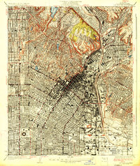
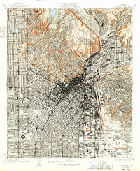
1928 Map of Los Angeles
USGS Topo · Published 1928About this map
Los Angeles is revealed here as a rapidly maturing metropolis, surveyed just before the Great Depression began. The dense urban core radiates outward across a geometric street grid, bounded by the Los Angeles River and the rising elevations of Elysian Park and San Rafael. Major thoroughfares like Sunset Blvd and Wilshire Blvd are already established as primary arteries, while the presence of the Pacific Electric and Union Pacific railroads underscores the city's reliance on rail transport for both passengers and commerce.
Find a feature on this map
30 named features on this map. Tap any name to fly to it.
Don’t see what you’re looking for? This feature index may not catch every label — zoom into the map to look around manually.
Map Details
Editions of this 1928 Los Angeles Map
2 editions found
Other maps of this area

1894 · Los Angeles
USGS Topo · 1:62,500

1896 · Pasadena
USGS Topo · 1:62,500

1896 · Redondo
USGS Topo · 1:62,500

1896 · Santa Monica
USGS Topo · 1:62,500

1896 · Downey
USGS Topo · 1:62,500

1898 · Santa Monica
USGS Topo · 1:62,500

1899 · Downey
USGS Topo · 1:62,500

1900 · Pasadena
USGS Topo · 1:62,500

1900 · Los Angeles
USGS Topo · 1:62,500

1901 · Southern California Sheet No. 1
USGS Topo · 1:250,000