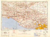
1949 Map of Los Angeles
USGS Topo · Published 1949About this map
The San Gabriel Mountains and Santa Monica Mountains dominate the landscape of this 1940s survey, showing the Southern California region before its postwar suburban explosion. Urban development is concentrated in established centers like Pasadena, Alhambra, and Glendale, linked by early transit corridors including the Pacific Electric and Southern Pacific railroads. The map captures a transition in mobility, featuring both the Pasadena Freeway and the storied Ridge Route winding through the high country.
Find a feature on this map
194 named features on this map. Tap any name to fly to it.
Don’t see what you’re looking for? This feature index may not catch every label — zoom into the map to look around manually.
Map Details
Editions of this 1949 Los Angeles Map
2 editions found

Other maps of this area

1894 · Los Angeles
USGS Topo · 1:62,500

1894 · Pomona
USGS Topo · 1:62,500

1896 · Pasadena
USGS Topo · 1:62,500

1896 · Anaheim
USGS Topo · 1:62,500

1896 · Redondo
USGS Topo · 1:62,500

1896 · Santa Monica
USGS Topo · 1:62,500

1896 · Downey
USGS Topo · 1:62,500

1897 · Pomona
USGS Topo · 1:62,500

1898 · Pomona
USGS Topo · 1:62,500

1898 · Santa Monica
USGS Topo · 1:62,500