
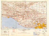
1949 Map of Los Angeles
USGS Topo · Published 1949About this map
Santa Barbara and the coastal corridor of Southern California appear here just after the war, showing a region defined by its rugged topography and expanding infrastructure. The city of Los Angeles anchors the southeast, with early suburban growth spreading through the San Fernando Valley toward Burbank and Van Nuys. Inland, the map captures the transition from the densely settled coastal plains to the massive wilderness of the Los Padres National Forest and Angeles National Forest.
Find a feature on this map
156 named features on this map. Tap any name to fly to it.
Don’t see what you’re looking for? This feature index may not catch every label — zoom into the map to look around manually.
Map Details
Editions of this 1949 Los Angeles Map
2 editions found
Other maps of this area

1894 · Los Angeles
USGS Topo · 1:62,500

1894 · Pomona
USGS Topo · 1:62,500

1896 · Pasadena
USGS Topo · 1:62,500

1896 · Anaheim
USGS Topo · 1:62,500

1896 · Redondo
USGS Topo · 1:62,500

1896 · Santa Monica
USGS Topo · 1:62,500

1896 · Downey
USGS Topo · 1:62,500

1897 · Pomona
USGS Topo · 1:62,500

1898 · Pomona
USGS Topo · 1:62,500

1898 · Santa Monica
USGS Topo · 1:62,500