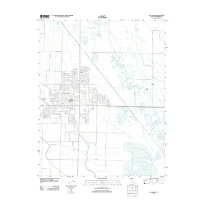
2012 Map of Los Banos
USGS Topo · Published 2012About this map
Los Banos and its surrounding agricultural landscape are defined by an intricate network of irrigation and drainage infrastructure in the San Joaquin Valley. The city's northern expansion is bounded by the Los Banos Game Bird Farm and industrial parcels, while the eastern fringes are dominated by the San Pedro Canal and Mud Slough Bypass. This 2012 survey illustrates the importance of water management in Merced County, showing how the West Delta Canal and Midway Canal segment the fertile lowlands. Local history and genealogy interest is concentrated near the southern city limits at Los Banos Cem and Calvary Cem. Beyond the residential blocks, the terrain gives way to significant water bodies like Big Water Lake and the marshy expanses of Mud Slough, alongside specialized agricultural operations such as Rodoni Dairy Farms.
Find a feature on this map
117 named features on this map. Tap any name to fly to it.
Don’t see what you’re looking for? This feature index may not catch every label — zoom into the map to look around manually.
Map Details
Editions of this 2012 Los Banos Map
This is the sole edition of this map. No revisions or reprints were ever made.
Other maps of this area

1913 · Panoche
USGS Topo · 1:125,000

1916 · Delta Ranch
USGS Topo · 1:24,000

1918 · Turner Ranch
USGS Topo · 1:31,680

1919 · San Luis Ranch
USGS Topo · 1:31,680

1919 · Ingomar
USGS Topo · 1:31,680

1920 · Carrisalito Spring
USGS Topo · 1:31,680

1921 · Volta
USGS Topo · 1:31,680

1921 · Los Banos
USGS Topo · 1:31,680

1922 · Charleston School
USGS Topo · 1:31,680

1922 · Dos Palos
USGS Topo · 1:31,680