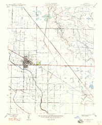
1947 Map of Los Banos
USGS Topo · Published 1947About this map
Los Banos is the central hub of this post-war San Joaquin Valley landscape, showcasing an intricate network of irrigation and transportation that defined mid-century Merced County. The grid-patterned town is flanked by the Airport and the small settlement of Abatto to the east. Agriculture dominates the terrain, evidenced by the dense web of waterways including the Main Canal, Arroyo Canal, and Mercy Canal, which redirected water across the arid flats. The map captures a moment when rail was still vital, featuring the Southern Pacific and Santa Fe lines cutting diagonally through the territory. To the northeast, the landscape shifts toward the marshy San Jon de Santa Rita and the winding course of Mud Slough, where the Los Banos Gun Club stands near the Delta West Drain. This survey documents the intersection of large-scale engineering and local ranching life, punctuated by numerous Windmills dotting the valley floor.
Find a feature on this map
19 named features on this map. Tap any name to fly to it.
Don’t see what you’re looking for? This feature index may not catch every label — zoom into the map to look around manually.
Map Details
Editions of this 1947 Los Banos Map
This is the sole edition of this map. No revisions or reprints were ever made.
Other maps of this area

1913 · Panoche
USGS Topo · 1:125,000

1916 · Delta Ranch
USGS Topo · 1:24,000

1918 · Turner Ranch
USGS Topo · 1:31,680

1919 · San Luis Ranch
USGS Topo · 1:31,680

1919 · Ingomar
USGS Topo · 1:31,680

1920 · Carrisalito Spring
USGS Topo · 1:31,680

1921 · Volta
USGS Topo · 1:31,680

1921 · Los Banos
USGS Topo · 1:31,680

1922 · Charleston School
USGS Topo · 1:31,680

1922 · Dos Palos
USGS Topo · 1:31,680