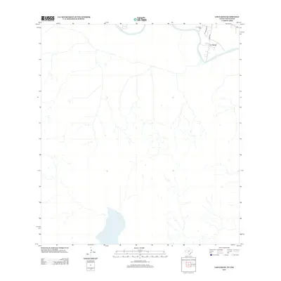
2013 Map of Los Garzas
USGS Topo · Published 2013About this map
The Rio Grande serves as a stark international boundary in this 2013 survey, winding through the arid terrain between Texas and Tamaulipas. On the northern bank, the small settlement of Los Garzas sits near the river's edge, characterized by a sparse grid of local roads and quiet residential properties. The local heritage of the area is anchored by the Los Garzas Cem, a significant site for genealogists and family historians researching the borderlands. The landscape is defined by its rural transit network, including Midway Rd and the residential loops of Se Pulvedas Cir. This map captures a modern view of a long-established ranching and river community, where the proximity to the water has shaped the pattern of development and land use for generations.
Find a feature on this map
5 named features on this map. Tap any name to fly to it.
Don’t see what you’re looking for? This feature index may not catch every label — zoom into the map to look around manually.
Map Details
Editions of this 2013 Los Garzas Map
This is the sole edition of this map. No revisions or reprints were ever made.
Other maps of this area

1949 · Mc Allen
USGS Topo · 1:250,000

1954 · McAllen
USGS Topo · 1:250,000

1956 · Escobares
USGS Topo · 1:62,500

1956 · Roma
USGS Topo · 1:62,500

1957 · Mc Allen
USGS Topo · 1:250,000

1962 · McAllen
USGS Topo · 1:250,000

1965 · Rio Grande City South
USGS Topo · 1:24,000

1965 · Los Garzas
USGS Topo · 1:24,000
1965 · Rio Grande City North
USGS Topo · 1:24,000
1965 · Roma-Los Saenz East
USGS Topo · 1:24,000