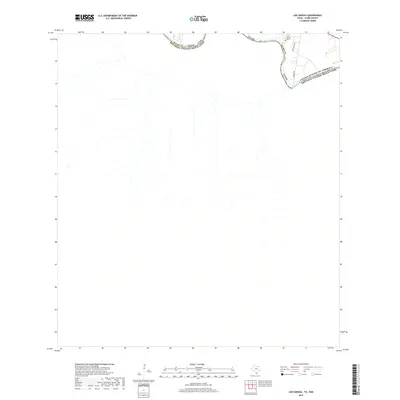
2019 Map of Los Garzas
USGS Topo · Published 2019About this map
The Rio Grande snakes along the international boundary between Texas and Mexico in this borderlands survey. Situated in Starr Co, the landscape is defined by the sharp bend of the river as it flows between the United States Of America and the Estados Unidos Mexicanos. The map documents a sparsely populated corridor where local transit is facilitated by routes such as S Midway Rd and Sepulveda Cir. Of particular interest to genealogists and local historians is the Los Garzas Cem, located near the northern bank. This small cemetery and the surrounding residential grid represent a quiet settlement pocket along the river's edge, highlighting the enduring nature of communities in the Rio Grande Valley.
Find a feature on this map
9 named features on this map. Tap any name to fly to it.
Don’t see what you’re looking for? This feature index may not catch every label — zoom into the map to look around manually.
Map Details
Editions of this 2019 Los Garzas Map
This is the sole edition of this map. No revisions or reprints were ever made.
Other maps of this area

1949 · Mc Allen
USGS Topo · 1:250,000

1954 · McAllen
USGS Topo · 1:250,000

1956 · Escobares
USGS Topo · 1:62,500

1956 · Roma
USGS Topo · 1:62,500

1957 · Mc Allen
USGS Topo · 1:250,000

1962 · McAllen
USGS Topo · 1:250,000

1965 · Rio Grande City South
USGS Topo · 1:24,000

1965 · Los Garzas
USGS Topo · 1:24,000
1965 · Rio Grande City North
USGS Topo · 1:24,000
1965 · Roma-Los Saenz East
USGS Topo · 1:24,000