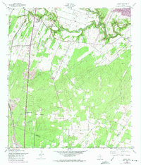
1958 Map of Losoya
USGS Topo · Published 1975About this map
The Medina River carves a winding path through the northern landscape of this Bexar County region, anchoring a rural community defined by its religious and educational centers during the late 1950s. The settlement of Losoya serves as a focal point, supported by institutional landmarks such as Our Lady of Mt Carmel Ch and the South Side High Sch. Transportation and industry are marked by the Missouri Pacific railroad corridor and local extractive sites like the Gravel Pit.
Find a feature on this map
20 named features on this map. Tap any name to fly to it.
Don’t see what you’re looking for? This feature index may not catch every label — zoom into the map to look around manually.
Map Details
Editions of this 1958 Losoya Map
Other maps of this area

1953 · Terrell Wells
USGS Topo · 1:24,000

1953 · Elmendorf
USGS Topo · 1:24,000

1953 · Southton
USGS Topo · 1:24,000

1954 · San Antonio
USGS Topo · 1:250,000

1957 · San Antonio
USGS Topo · 1:250,000

1958 · Losoya
USGS Topo · 1:24,000

1958 · Thelma
USGS Topo · 1:24,000

1958 · Saspamco
USGS Topo · 1:24,000
1964 · Saspamco SE
USGS Topo · 1:24,000

1964 · Leming
USGS Topo · 1:24,000