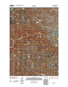
2011 Map of Lost Basin
USGS Topo · Published 2011About this map
Burnt River carves through this portion of Baker County, creating the prominent Burnt River Canyon that dominates the central landscape. The terrain is defined by its water management and livestock history, evidenced by features like Kirby Reservoir, True Blue Reservoir, and the Banks Ditch irrigation line. Strategic water access points such as Benchmark Waterhole, Coyote Waterhole, and Powell Spring are scattered across the higher elevations near Sheep Mountain. In the south, the namesake Lost Basin sits near the headwaters of Powell Creek. This area remains largely undeveloped, with movement restricted to a few established paths like Cave Creek Rd and Rye Valley Ln, which provide access to the remote gulches and drainages typical of the eastern Oregon high country.
Find a feature on this map
25 named features on this map. Tap any name to fly to it.
Don’t see what you’re looking for? This feature index may not catch every label — zoom into the map to look around manually.
Map Details
Editions of this 2011 Lost Basin Map
This is the sole edition of this map. No revisions or reprints were ever made.
Other maps of this area

1901 · Baker City
USGS Topo · 1:125,000

1915 · Pine
USGS Topo · 1:125,000

1951 · Huntington
USGS Topo · 1:62,500

1955 · Baker
USGS Topo · 1:250,000

1957 · Durkee
USGS Topo · 1:62,500

1959 · Baker
USGS Topo · 1:250,000

1964 · Bridgeport
USGS Topo · 1:62,500

1967 · Encina
USGS Topo · 1:24,000

1967 · French Gulch
USGS Topo · 1:24,000

1967 · Lost Basin
USGS Topo · 1:24,000